![[Hiking] Caldera de la Rilla and Montaña del Señalo](https://www.coolturalanzarote.com/wp-content/uploads/bfi_thumb/dummy-transparent-nyrhk6ok1momxa35u7oyaitn4vsrxa16ib9bmpndfc.png "[Hiking] Caldera de la Rilla and Montaña del Señalo")
[Hiking] Caldera de la Rilla and Montaña del Señalo
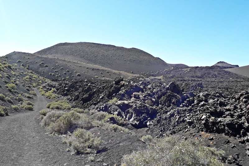
The Volcanoes Natural Park forms a natural geological museum where the beauty of the landscapes contrasts with the play of light painted in the sky by volcanic lava and its forms. This immense collection of protuberances offers the hiker countless options to walk among volcanoes, mostly well signposted.
Once in the mouth of the Caldera de la Rilla, the view of the Volcanoes Natural Park is spectacular. Just in the other direction, imposing, the Montaña del Señalo. The path passes between both formations. But from above, besides being able to observe the depth of the Caldera, you can see the rest of its neighbors: Pico Partido, Caldera Blanca, Islote de Hilario …
In the words of Agustín Pallarés, obtained in turn from his local informants, the Montaña de la Rilla (also called Caldera de la Rilla) is so called because inside the crater grows a so-called grass that the peasants of the place use as forage for their animals.
Both formations are located in the volcanic area of Pico Partido-Montaña del Señalo (landmarks that mark the beginning and end of the area). It constituted one of the most active points of the eruptive fissure of the eruption of 1730-1736. This makes it one of the areas with more eruptive centers per km2: cones and craters formed in different phases and with varied eruptive styles and linked to fractures not always of the same direction, which determines the generation of an eruptive group of irregular shape, great development in height and high morphological variety.
How to get
Both formations are located very close to the boundaries of the Timanfaya National Park. Exactly located in Tinguatón in the municipality of Tinajo. To get there you have to head towards Tinajo taking the L-67 until you reach the ample car park that is there before reaching the municipality. There are several options. The first is to park the car in that same parking lot and start walking along the dirt road. This would add about 4 kilometers to the trail (2 outbound and 2 back). The other is to get closer with the car to the Montaña de Los Rodeos and park it right at the base of the mountain. Once there, take the path on the right and continue on it. In our case we wanted to surround both the Caldera de la Rilla and also, on the way back, the Montaña de Los Rodeos. To do it this way, in the two forks that you find during the trail you have to take the right path.
Duration
This return between volcanoes has a length of just under 7 kilometers. With the corresponding stops to drink water, the estimated time is about two hours. If you decide to take the road from the parking lot, it would be about 11 kilometers and about 3 hours of walking.
Difficulty
Low
Recommendations
Bring water. Collect all the generated waste. Do not leave the marked path, or step on the volcanic formations.
